![]() YERKES
YERKES![]()
SURVEYING CONSULTANTS
|
GPS
|
||
|
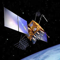
GPS is the Global Positioning System. GPS uses satellite technology to enable a terrestrial terminal to determine its position on the Earth in latitude and longitude. GPS receivers do this by measuring the signals from three or more satellites simultaneously and determining their position using the timing of these signals. GPS operates using trilateration. Trilateration is the process of determining the position of an unknown point by measuring the lengths of the sides of an imaginary triangle between the unknown point and two or more known points.
For additional information, visit
|
|
|
|
A little GPS history
Yerkes Surveying Consultants, now a part of DuBois & King, Inc., can fully leverage new GPS and portable computing technologies for field operations, as well as facilitate integration between conventional land based survey data, aerial photography and GPS according to our clients needs. Often, we will employ both land based and GPS techniques in order to best meet the challenges of New Hampshire's terrain. |