![]() YERKES
YERKES![]()
SURVEYING CONSULTANTS
|
Photogrammetry Control
|
||
|
||
|
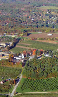
Aerial Topography Mapping and PhotogrammetryAerial Photogrammetry and Topographic Mapping is generally used to map large areas that would not be cost effective to map using conventional ground survey methods. This type of mapping shows land contours, site conditions and details for large areas. Ground control surveys must be used to establish control measurements and elevations in order to create the photographic model.
For additional information, visit
|
||
|
Yerkes Surveying Consultants, now a part of DuBois & King, Inc., has extensive experience in the layout of geodetic control for use in preparing aerial topographic mapping. We work closely with New Hampshire aerial photogrammetry specialists to provide quality products that suit your individual project requirements. |
2023 ALL RIGHTS RESERVED - DUBOIS & KING, INC.